Page 52 of 61
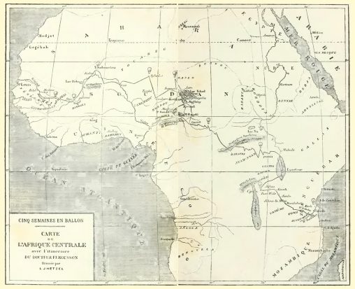
Mapa retirado do livro “Cinq semaines en ballon”, de Jules Verne (pág. 180-181. 1863, ilustração de Édouard Riou).

Carte des régions Circumpolaires Dressée pour le voyage du Capitaine J. Haterras par Jules Verne 1860-1861 Ilustração original retirada do livro Jules Verne, Voyages et aventures du Capitaine…


Dymaxion projection basemap The Dymaxion map, invented by Buckminster Fuller and originally published in 1943, is a projection of a world map onto the surface of an icosahedron, later unfolded and flattened to…

Monte Análogo, continente insular no Sul do Pacífico, onde se encontra a mais alta montanha do planeta. A sua existência nunca foi reconhecida já que toda a área…

One of Henry Holiday’s original illustrations to “The Hunting of the Snark” by Lewis Carroll, 1876. From Fit the Second: The Bellman’s Speech: […] He had brought a…

‘Mildred’ struck in thick fog at midnight on April 6th, 1912. This boat was carrying slag from Newport to London. When it began to pound broadside on, the captain and…